Exhibit looks at maps as art and science
Cal Lutheran professor's collection dates to the 1500s
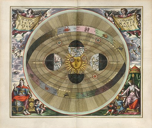
“Scenographia: Systematis Copernicani” by German cartographer Andreas Cellarius was published in 1660.
(THOUSAND OAKS, Calif. – Sept. 17, 2018) Both the science and art of maps are highlighted in the collection of a local resident on exhibit at California Lutheran University.
“Mapping Meaning: Adventures in Cartography” will be on display in the William Rolland Gallery of Fine Art on the university’s Thousand Oaks campus through Nov. 6.
Ernst F. Tonsing, the Cal Lutheran professor emeritus who amassed the collection, will speak at two related events during Homecoming weekend. The Thousand Oaks resident will discuss “Facts, Frauds and Fictions: Mapping the Top of the World” at 4 p.m. Friday, Oct. 19, in Room 212 of the William Rolland Art Center. And he will lead a tour of the exhibit at 2 p.m. Saturday, Oct. 20.
Once stashed in glove compartments and now accessed on our phones, maps are an attempt to impose order on unruly geography. Their interpretations, however, are subject to the shaping influences of time and power. Coastlines are altered by rising sea levels, lands are “discovered” and boundaries are disputed and changed.
Some maps are political statements and some are fanciful. Some are mistaken, inserting an island or angling a lake at odds with reality. Maps can reveal perspectives and priorities of the people commissioning or making them.
This exhibit presents a variety of maps and ways of reading them, along with cultural objects from the times of their creation. Works date from the 16th century to the present, including a collection focusing on Scandinavia, a depiction of California as an island, and maps of the heavens.
“A lot of these are works of art,” Tonsing said. “Sometimes, they are quite beautiful.”
Tonsing loved maps as a child because they helped him figure out where he was while moving from state to state with his military family. He learned to read geological maps in a college class and became skilled at interpreting nautical maps as a U.S. naval officer. In the nearly 30 years he was on the Cal Lutheran faculty, maps figured prominently in the religion and Greek classes he taught and in the study tours he led to Greece and the Middle East. About 30 years ago, he started collecting antique maps. He now has more than 40, most of which are in the exhibit.
Admission to the exhibit and events is free. The gallery is open from 10 a.m. to 4 p.m. Tuesday through Friday and 11 a.m. to 3 p.m. Saturday. It is located in William Rolland Stadium on the north side of Olsen Road between Campus Drive and Mountclef Boulevard. The art center is just west of the stadium.
For more information, contact curator Rachel T. Schmid at 805-493-3697 or rollandgallery@callutheran.edu, or visit CalLutheran.edu/rolland.